Monday, 10 July 2017

GMT-5; another leg of the Greenwich Meridian Trail

GMT-5: from Titsey to Addington

A minor scare about rain all day melted away and so as this was our "Plan A" route for the day off we set. Actually it turned out to be a great day with plenty of sun and just a tad hotter than we would have liked but still a great walk day.

We had debated this leg as technically it took us into the Greater London area and we wondered if it would a) be boring and b) too cosmopolitan to be a good walk. However, the map said otherwise and so we took the chance and indeed probably 90% of the trail was through mixed countryside and was a very good section indeed.

Starting out from the Titsey car park that we now know very well, we had to tread the North Downs Way for the first mile before picking up the GMT trail and turning North. The trail to Woldingham was delightful and mostly downhill but as we often say, once downhill the next has to be "Uphill" and the next half-mile was one of the steepest walks we have done for a couple of years. So steep in fact that we had to take a rest stop at the top to get the heart and lungs back into normal pace.

Once up it wasn't too bad and we made good time through the oddly named "Worms Heath" towards our target for lunch at another fascinating named village of Fickleshole. It was on this stretch that we started to hit trouble with over-growth, first with a farmer whose crop of field beans had grown over the path and the field verge was so overgrown with nettles and grass that it was impossible to walk on. We pushed on however and eventually exited this field only a few hundred yards further on to meet a wall of nettles and Cows Parsley so thick that it was almost impossible to push through it. Eventually we were able to climb out into the field next to the trail and find an alternative route. So it was a very tired trio that eventually reached "The White Bear" pub for lunch.

Refreshed we set off towards New Addington, an overspill housing estate built to accommodate the expanding city of Croydon in the 1930's. Originally intended to be one of the "Garden Cities" the second world war stopped the project in its tracks and it wasn't until the 1960's that the town stated to grow and get the services it deserved, However, one aspect that was very noticeable as we walked through the town was the abundance of "Green Spaces" and mostly we were walking across parkland or along grass corridors and not roads. (see New Addington Wiki ).

Most of this section took us down a wooded corridor about 2 miles in length and we knew we were in a heavily populated urban area only by the number of burnt out motorcycles that littered the side of the path! We must have passed about a dozen of them and clearly the bored youth of the area would run amok along the woodland trails in the evenings on the stolen motorbikes before "torching" them. Glad it was mid afternoon for us!

 
Top of the North Downs 
 
Looking across the Weald of Kent 
 
Struggling up the "hill" - Trevor is the last man up!
 
Across the North Downs from Woldingham Hill
 
Lunch Stop
 
Two old walkers taking a break!

Stats for the walk were ...

Finished Hike: 10 Jul 2017, 15:04:47
Route: GMT-5
Hike Time: 3:16:57
Stopped Time: 1:10:26
Distance: 10.03 miles
Average: 3.1 mile per hr
Fastest Pace: 13:08 min/mile
Ascent: 1328 feet
Descent: 1998 feet

Calories: 1048

Monday, 3 July 2017

Around Horsted Keynes

Horsted Keynes and the Weald

Our good friends at Fancy Free Walks had posted a new walk but it was only 5 miles long. HOWEVER, it did show a new pub that we had not used previously and so we set about mapping a route in the usual manner! Work back 6 miles from the pub and then try and find a decent parking spot. This gives you a reasonable start point. Then work out the route beyond the pub in either a loop back to the car or to a bus stop that would get us back to the car. By this methodology, we ended up with a 10 mile loop walk starting at the car park at Horsted Keynes Station and it was a very nice walk too.

The village of Horsted Keynes is a pretty place and we walked through it and into lovely Weald countryside until we reached Danehill. From here we dropped down the hill to Chelwood Common where the "Coach & Horses" waited for our custom. This was a delightful little pub and well worth visiting.

We headed north from the pub and after crossing two paths we have walked previously - The Greenwich Meridian and the Sussex Border paths - we reached the railway line and followed it the last mile or so back to the car.

We spotted a single Red Kite flying across the Weald today and so it seems these birds are slowly expanding out of their Oxfordshire stronghold to our region which is great because they make a delightful sight.

 
Village pond
 
Cloudy day over the Weald
 
Lunch stop at the Coach & Horses
 
The Coach & Horses

Stats for the day were...

Finished Hike: 3 Jul 2017, 20:41:45
Route: Horsted Keynes Loop
weather:
temperature20°C
humidity68%
wind9 mph SSW
Hike Time: 3:38:20
Stopped Time: 1:01:04
Distance: 10.70 miles
Average: 2.94 mile per hr
Fastest Pace: 15:18 min/mile
Ascent: 1692 feet
Descent: 1701 feet

Calories: 1166

Monday, 26 June 2017

Greenwich Meridian Trail section 5

GMT-5 from Lingfield to Titsey Park

After last week's mammoth walks we decided to walk this section from North to South and  the very big reason for this is that the top of Titsey park is at the top of the North Downs. IF we had walked from Lingfield northwards at the end of the 9 or so mile walk is a bloody great hill; but walking the way we did gave us a great downhill section at the start and the rest of the way was pretty flat.

We met up where we parked last time on the outskirts of Lingfield and then drove in one car up to the small car park on the top of the N Downs. This was just about a mile off the actual trail but the only realistic place we could leave a car for most of the day.

We didn't make a good start, taking a side trail that fizzled out and left us going round in a circle trying to find a route down to the path we needed. That over with, the rest of the walk went on with little trouble although the scarcity of signage and way markers meant the GPS worked hard. There seemed to be more road walking than normal but generally they were very small quiet roads and the country sections were a good mix of woodland and open fields.

Arriving back at Lingfield we had a real thirst on so quickly drove down the road to a new pub for us "The Star" and it was very good.

 
Walking across the River Eden valley
 
Big Sky and active plane trails over the North Downs
 
Lunch stop at The Star in Lingfield

Stats for the day were...

Finished Hike: 26 Jun 2017, 14:00:06
Route: GMT-5
Weather: 
temperature19°C
humidity52%
wind8 mph NE
Hike Time: 3:08:00
Stopped Time: 20:00
Distance: 9.90 miles
Average: 3.16 mile per hr
Fastest Pace: 13:52 /mile
Ascent: 1427 feet
Descent: 2113 feet

Calories: 1037

Friday, 23 June 2017

Some history on "Boys Walk Holidays"

Comparison of our "Walk Week" stats


I decided that we needed to check if we were getting fitter as the years progress., so I drew up this simple comparison of our annual boys outings.

Walk Holiday
Total distance walked miles
Total height climb Ft
Total Calories
Lake District 2014
24.42
6,001
3,775
Weymouth Coast 2015
28.48
4,851
3,386
Llangollen Wales 2016
32.58
5,422
2,998
Marlborough Downs 2017
37.19
6,516
2,485

So actually we are "holding our end up" pretty well. This week we have walked more miles than any other holiday and also climbed more height. OK, we are down a bit on energy used - must be that age creeping up on us - but generally we put in a very good show under extreme duress with the hottest UK temperatures since 1967.

Well done the Septuagenarians !

Boys walking week day 4

Hunting the White Horse

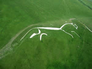
We had to leave our lovely little Inn with the Well (yes, it did have an old well right in the middle of the bar) to travel home but we wanted to do so via another section of the Ridgeway Trail which goes past Uffington Castle; another Long Barrow and most importantly, the oldest hill sculpture in Europe, The Uffington White Horse which is at least 3,000 years old and according to The Guardian newspaper "for more than 3,000 years, the Uffington White Horse has been jealously guarded as a masterpiece of minimalist art." see White Horse


We drove to the car park a few hundred yards from the site and set off in search of the beast which is 110 m (360 ft) long and one of the largest such figures in existence. Looking for info on the internet the previous day had warned us that this beast was not at all easy to see as in truth, it can ONLY be seen fully from the air!

How right they were. We walked up hills as steep as a seaside cliff; down deep valleys and up and around the horse but all we ever got was a partial view. Currently visitors are urged to keep off the monument itself and we obeyed this. But we would probably have seen even less up that close.

So we set off to find Uffington Castle, another Iron Age fort and very similar in construction to Barbury Fort that we visited two days previously. (Uffington_Castle) We then picked up the Ridgeway Trail again and walking westward followed it for about a mile or so to "Waylands Smithy" another Neolithic ancient burial Long Barrow very similar in construction to the West Kennet one. See Wayland Smithy

We could have walked a few more miles but after the two long previous walks in very hot weather the legs and feet were feeling the strain so we back-tracked to the car park, found a pub in Uffington for lunch, then drove home.


Looking down the "Long Barrow"
 
Is that a Ghost behind me!


Stats for the day were ...

Finished Hike: 22 Jun 2017, 12:49:10
Route: Uffington White Horse
Weather: 
temperature19°C
humidity81%
wind12 mph WSW
Hike Time: 1:26:47
Stopped Time: 54:43
Distance: 4.45 miles
Average: 3.07 mile per hr
Fastest Pace: 15:05 /mile
Ascent: 1175 feet
Descent: 1195 feet

Calories: 442

Wednesday, 21 June 2017

Boys walking week to Marlborough - Day 3

Along the White Horse way

On the hottest day since 1987 - 34 deg C - we had to take a 10 mile walk! As Trevor said most 70 year olds would be sitting in the shade in a care home with a cold beer in one hand and a copy of Playboy in the other so we must be getting twinges of Dementia to go out and walk in this heat.

We had a small section of shade as we walked through "West Woods" but for most of the walk we had burning sun and had to search for shade every 30 mins or so to take rests. In the end we cut a mile or so from our planned route in order to complete it earlier and get refreshment back in Marlborough. Cold Coke never tasted so good.

Anyway - this was a very scenic walk that took us along another marked trail called "The White Horse Way". This led us out of Marlborough and through West Woods and up to Huish Hill. Now we approached the hill from its lee side and from the top of the ridge there is an immensely steep downhill drop which fortunately we didn't have to take.

From here we picked up the Mid-Wilts way which took us westward along the top of the ridge for about 4 miles, giving us tremendous views. We could have enjoyed it more if it hadn't been 34 deg C and we were on a ridge with no shade!

By the time we got to Knap Hill we decided that we needed a small "Course Correction" before we wilted and we turned up the "Ridgeway" trail northwards back to West Overton which cut about 1.5 miles from our intended route. On the way at East Kennet we came across another small stone circle - more evidence of the amazing history of this region.


Looking out over Marlborough
 
Amazing wild flowers up on the downs
 
We reach the edge of Oare ridge
 
Walking West along White Horse Ridge


Photos just don't show the steepness of the valleys and the drop from the ridge


East Kennet Stone Circle


Stats for the walk were...

Finished Hike: 21 Jun 2017, 17:57:34
White Horse Way
Weather:
temperature26°-32°C
humidity82%
wind7 mph E
Hike Time: 3:49:31
Stopped Time: 1:27:56
Distance: 11.68 miles
Average: 3.05 mile per hr
Fastest Pace: 14:25 /mile
Ascent: 1958 feet
Descent: 1934 feet

Calories: 1208